

Pine Creek Valley: A Landscape Written in Stone, Water, and Sweat

It has been many weeks since I've written a blog. Between Ironstone last weekend and Eastern States 100 right around the corner, there hasn't been much time to sit down with my proverbial bottle of cheap bourbon, an unfiltered Marlboro, and my trusty IBM Selectric 251.
While digging through some old files, I found a series of posts I wrote over the years about the Tiadaghton region. With Eastern States almost here—and as we celebrate America's 250th anniversary—it seemed like the perfect time to dust them off, update them, and share them again.
Over the next few chapters, we'll look at the forces that shaped the Pine Creek Valley, a little-known Declaration of Independence that happened here on the very same day as Philadelphia's, and how lumber transformed one of Pennsylvania's wildest landscapes.
Let's start where every good trail story begins—with the ground beneath your feet.
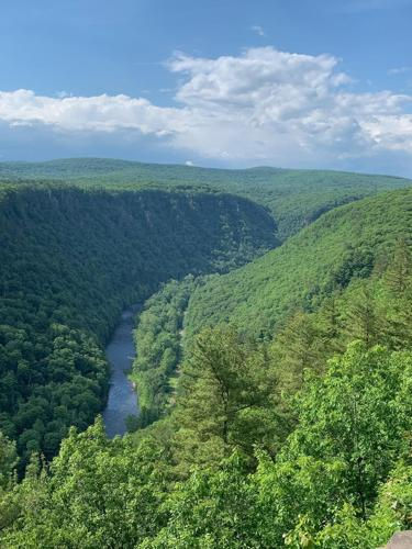
Chapter 1: Pine Creek Valley — "There Are No Mountains Here"
As you toe the line at Eastern States 100, you'll hear people talk about "the mountains."
Technically, there aren't any.
The course doesn't climb mountains... it traverses a dissected plateau. The ridges you'll spend the next 103 miles climbing and descending are remnants of the Allegheny Plateau, carved apart by water over millions of years. Every brutal descent into a hollow and every relentless climb back out exists because of geology, not mountain-building.
You can blame ice, water, and a ridiculous amount of time.
Pine Creek itself stretches 87 miles before joining the West Branch Susquehanna River. It flows through Potter, Tioga, Lycoming, and Clinton counties and is designated a Pennsylvania Scenic River. Despite the name, it's often called the largest creek in the United States. Anywhere else, it would probably be considered a river.
Its story took a dramatic turn roughly 20,000 years ago during the last Ice Age.
Originally, Pine Creek flowed north into New York through the Tioga and Chemung Rivers. Then the retreating Laurentide Ice Sheet left behind a massive wall of glacial debris near present-day Ansonia, damming the valley and creating a temporary lake.
Eventually, the water found a new outlet.
When that natural dam failed, the flood reversed the creek's direction, sending it south toward the Susquehanna River. That catastrophic overflow began cutting the enormous gorge we know today as the Pine Creek Gorge, aka the "Grand Canyon of Pennsylvania."
For nearly 47 miles, Pine Creek slices through the plateau. Near Waterville, the canyon reaches nearly 1,450 feet from rim to creek, making it one of the deepest gorges east of the Mississippi.
The entire watershed covers nearly 1,000 square miles, making it the largest tributary basin feeding the West Branch Susquehanna.
The Iroquois called it Tiadaghton, generally translated as either The River of Pines or The Lost or Bewildered River.
Either translation feels appropriate after about mile 80 of Eastern States.
Today the gorge is protected as a National Natural Landmark, with Leonard Harrison and Colton Point State Parks overlooking opposite rims. Although Pine Creek was considered for the original National Wild and Scenic Rivers program in 1968, local opposition kept it off the federal list. Pennsylvania eventually recognized its significance by designating it a State Scenic River in 1992.
The valley has continued evolving.
The last train rolled through the gorge in 1988. Less than a decade later, the abandoned rail line became the Pine Creek Rail Trail, stretching 61 miles from Wellsboro Junction to Jersey Shore. Earlier this year, DCNR named it Pennsylvania's 2026 Trail of the Year, recognizing both its recreational value and its role in helping revive the valley's economy.

Today, tens of thousands of visitors ride, hike, fish, paddle, and explore this corridor every year.
Eastern States offers a different way to experience it.
Over 103 miles, you'll climb the rims, descend into the hollows, cross ancient stream valleys, and follow ridgelines sculpted long before humans ever set foot here.
You're not conquering mountains.
You're running across the scars left behind by glaciers, rivers, and geologic time.
And those scars have been waiting a very long time for you.
Chapter 2: The Other Declaration of Independence
When Americans think of July 4, 1776, they picture Philadelphia.
Independence Hall. Thomas Jefferson. John Hancock's oversized signature. The ringing of the Liberty Bell (even if history tells us that part is probably more legend than fact unlike the time Nicholas Cage tried to heist it.)
But several days' journey to the northwest, in what is now the Pine Creek Valley, another group of Americans is said to have declared their independence on that very same day.
The odds that they knew what was happening in Philadelphia?
Essentially zero.
Long before Pine Creek became known for towering white pines or world-class trail running, it was the edge of the American frontier.
It was a place where maps were vague, laws were even vaguer, and survival depended far more on your neighbors than on any government hundreds of miles away.
The settlers living along Pine Creek found themselves caught in the middle of a disagreement that started with the Treaty of Fort Stanwix in 1768.
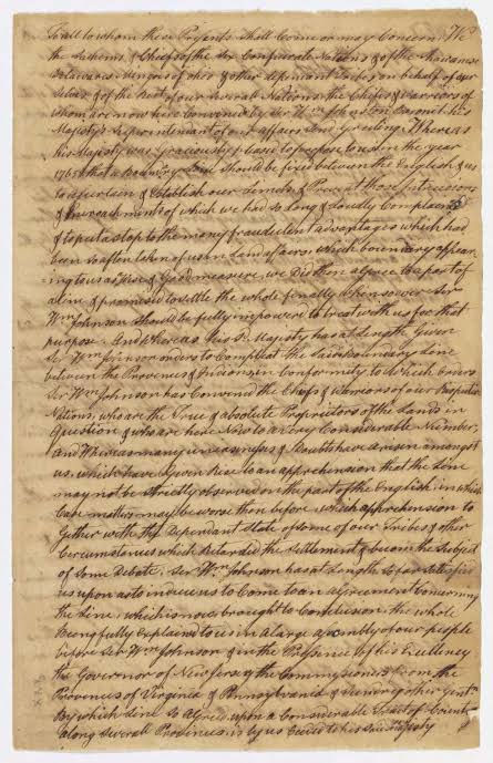
The treaty established a boundary between colonial settlements and Native American lands using a landmark called Tiadaghton Creek.
Simple enough except no one could agree which creek that actually was.
Colonial officials and the British government interpreted Tiadaghton Creek to mean present-day Lycoming Creek near Williamsport. The settlers believed it referred to Pine Creek, farther west.
That disagreement left hundreds of families in legal limbo.
To colonial authorities, they were squatters illegally occupying Native American land.
To themselves, they were simply farmers trying to build homes on what they believed was available land.
Since Pennsylvania's courts claimed no authority over them, the settlers did something remarkably American. They created their own government.
Known today as the Fair Play System, it was surprisingly simple. Three elected commissioners settled land disputes, heard disagreements, and served as the area's unofficial government.
There were no lawyers.
No appeals.
No bureaucracy.
Just neighbors settling problems among themselves.
Remarkably, it worked for nearly twenty years.
When the Revolutionary War broke out in April 1775, many of these settlers joined the Continental Army. Those who remained behind overwhelmingly supported independence.
According to stories, on July 4, 1776, they gathered beneath a massive American elm along the west bank of Pine Creek near its confluence with the West Branch Susquehanna River.
The tree became known as the Tiadaghton Elm.

There, the Fair Play Men declared themselves independent of Great Britain.
Unlike the delegates in Philadelphia, they weren't wearing powdered wigs or debating political philosophy. Their concerns were much more practical.
If America became an independent nation, perhaps their land claims would finally become legal.
Whether their declaration occurred on the exact same day as Philadelphia has been debated by historians for generations. Some believe the story has grown with time, while others argue the oral traditions are too consistent to dismiss entirely.
Either way, the symbolism remains remarkable.
On opposite sides of Pennsylvania, separated by forests and mountains, two groups of people reached the same conclusion. It was time to govern themselves.
The Fair Play Men selected two riders to carry news of their declaration to Philadelphia.
The journey did not go smoothly.
According to historical accounts, they were attacked by Native Americans, detained by Loyalists, and repeatedly delayed before finally reaching Philadelphia several days later.
Only then did they discover the astonishing coincidence.
The Continental Congress had adopted its own Declaration of Independence on the very day they had gathered beneath the Tiadaghton Elm.
Whether coincidence, legend, or a little of both, it's one of Pennsylvania's great frontier stories.
The Fair Play System disappeared after the Revolution.
As new treaties clarified land ownership and Pennsylvania extended its courts into the region, there was no longer a need for an independent frontier government.
The settlements themselves were burned during frontier raids in the Revolutionary War, rebuilt, and eventually absorbed into the growing Commonwealth.
The Tiadaghton Elm survived much longer.
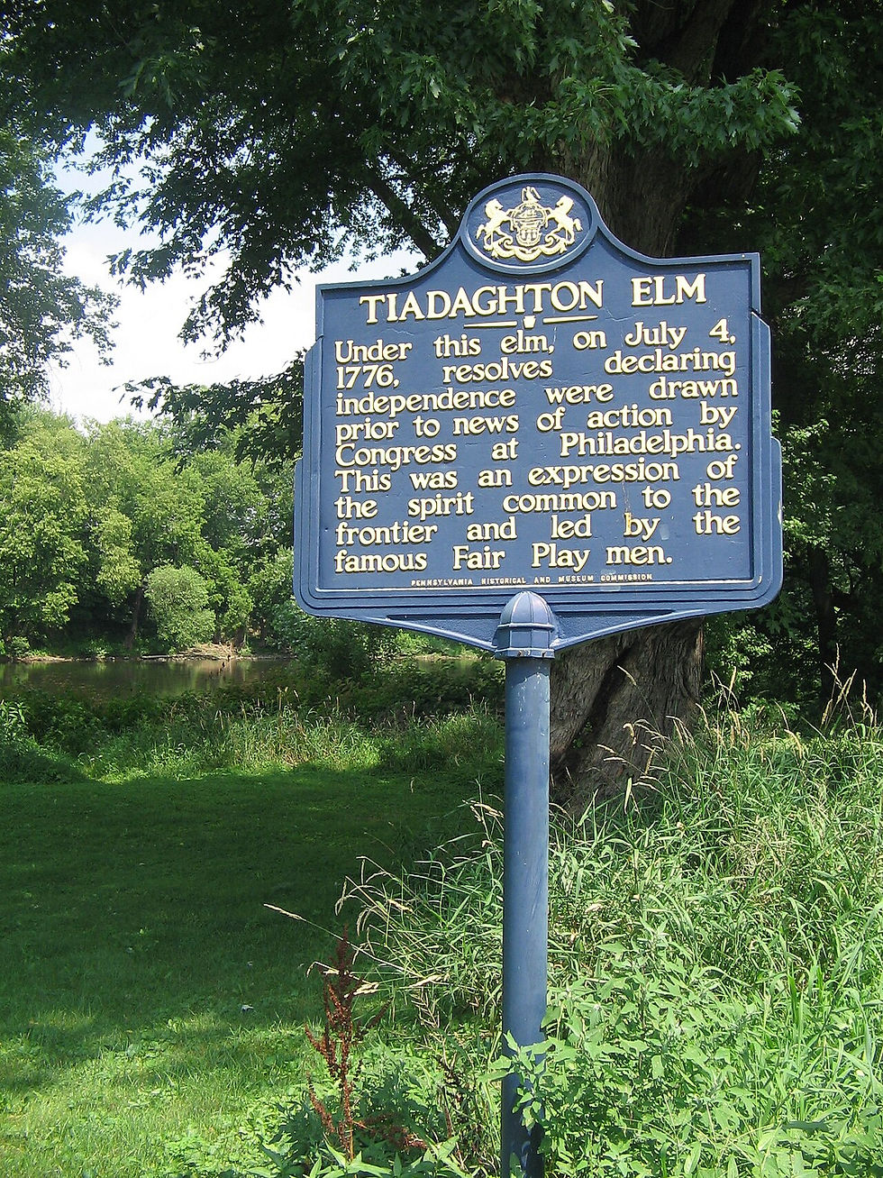
For nearly two centuries it stood as a landmark overlooking Pine Creek before finally succumbing to age in the 1970s. Today, visitors will find a historical marker and a quiet fishing access along the creek just a few miles from Jersey Shore. Most people drive past without ever realizing what happened there.
Yet every runner at Eastern States passes through a landscape where some of America's earliest experiments in self-government took place not in grand halls or state capitals, but in a clearing beneath a tree along the banks of Pine Creek.
History isn't always written in marble buildings.
Chapter 3: The Land of the Pirates
Today, it's hard to imagine the Pine Creek Valley as anything other than wilderness.
Runners at Eastern States weave through miles of hardwood forest, cross mountain streams, and stand atop overlooks that seem untouched by time. It's easy to believe this landscape has always looked this way.
It hasn't.
Just over a century ago, nearly every tree you see was gone.
When European settlers first entered the Pine Creek Valley, they encountered one of the greatest old-growth forests in eastern North America. The PA Wilds region was (and still is) the most expensive undeveloped region east of the Mississippi.
Eastern white pines towered 150 feet into the sky, many measuring three to six feet in diameter. Eastern hemlocks reached nine feet in circumference. Massive hardwoods filled every hollow and mountainside.
The numbers are almost difficult to comprehend.

An acre of virgin forest could produce nearly 100,000 board feet of white pine and another 200,000 board feet of hemlock and hardwoods. Today, a comparable acre averages only about 5,000 board feet.
It was an almost unimaginable natural resource. Shipbuilders certainly thought so.
Pine Creek white pine was considered among the finest mast timber in the world. Straight, tall, and nearly free of knots, it was prized for building the sailing fleets that connected the young nation to the world.
On March 16, 1798, the first rafts of giant spars floated down Pine Creek toward the Susquehanna River, eventually reaching Baltimore's shipyards.
A spar is simply a long timber used for a ship's mast or rigging, could sell for about a dollar, respectable money at the time. Three spars, sometimes ninety feet long, would be lashed together into a single mast raft before beginning their long trip downstream.
The largest spar cut along Pine Creek measured 43 inches in diameter twelve feet above its base, stretched 93 feet long, and still measured nearly three feet across at its upper end.
By 1840, Tioga County alone was sending more than 22 million board feet of lumber downstream every year.
The forests that had taken centuries to grow were disappearing in decades.
As the giant pines became scarce, the lumber industry adapted.
Hemlocks and hardwoods were cut in enormous quantities. Sawmills multiplied throughout the watershed. By 1840 there were 145 mills operating along Pine Creek and its tributaries, despite devastating floods that periodically swept many of them away.
Selective harvesting gave way to clear-cutting.
Everything came down.
In 1838, William E. Dodge and his partners established major lumber operations near what is now Leonard Harrison State Park. Thousands of acres changed hands as timber companies purchased nearly every forested ridge in the valley.
The last great pine spar floated down Pine Creek in 1865.
The age of floating individual masts had ended.
The age of industrial logging had arrived. To move ever-growing volumes of timber, Pennsylvania passed legislation in 1871 allowing splash dams to be built across mountain streams.
These temporary dams stored water behind them while thousands upon thousands of logs accumulated upstream.

When everything was ready, the gates were opened. A wall of water thundered downstream, carrying millions of board feet of timber toward the Susquehanna. Some spring log drives floated as much as 20 million board feet at one time.
It was spectacular.
It was dangerous.
And it transformed the valley forever.
If you've run Eastern States, you've passed through one of the race's most intriguingly named sections called the Algerine Wild Area, between Tomb Flats and Blackwell.
Most runners assume it's simply an unusual name but it actually tells a story.
In the 1800s, Algeria, on the northern coast of Africa, was widely associated in American culture with the Barbary pirates. The word "Algerine" eventually became slang for pirate or outlaw. That nickname found its way to Pine Creek.
Here, the "pirates" weren't sailing ships. They were stealing logs.
Each timber company marked its logs with a unique brand before sending them downstream. Lumber thieves intercepted those logs, sawed off the branded ends, stamped their own marks onto the fresh wood, and claimed ownership when the timber reached the mills.
These lumber pirates became so notorious that the surrounding hills earned the nickname The Algerine.

Even today, the name survives on maps long after the pirates disappeared.
White pine built ships.
Hemlock built another industry.
Its wood wasn't especially valuable at first, but its bark contained large amounts of tannic acid which is the key ingredient in turning animal hides into leather.
After 1870, the largest tanneries in the world operated within the Pine Creek watershed. Producing just 150 pounds of quality sole leather required nearly 2,000 pounds of hemlock bark.
Entire mountainsides were stripped simply to feed the tanning industry.
Nothing went to waste.
Except the forest itself.
By the early twentieth century, the old-growth forest was gone. The loggers left behind mountains of slash of dry limbs, tops, and debris that blanketed the hillsides.
Wildfires followed. Without tree cover, heavy rains washed away the thin mountain soils.
Landslides scarred the slopes.
Wildlife disappeared.
Newspapers began referring to parts of north-central Pennsylvania as the "Pennsylvania Desert."
Blueberries, blackberries, and nearly impenetrable mountain laurel replaced towering forests.
It was one of the greatest environmental disasters in Pennsylvania history.
Then something remarkable happened. The Commonwealth decided to buy it back.
Beginning in the early 1900s, the Commonwealth purchased hundreds of thousands of acres of cut-over land from timber companies.
During the Great Depression, the Civilian Conservation Corps established camps throughout what is now Tioga State Forest and neighboring public lands.
Young men planted millions of trees. They built roads, trails, fire towers, bridges, and recreational facilities. They fought fires. They stabilized streams.
Much of the forest runners experience today exists because of their work.
The wilderness of Eastern States isn't untouched. It's restored.
Like every chapter in Pine Creek's history, though, the story continues.
Beginning around 2005, another resource beneath these ridges transformed the landscape. Not timber.
Natural gas.


Advances in horizontal drilling and hydraulic fracturing unlocked the vast Marcellus Shale beneath the plateau. By 2018, wells within the Pine Creek watershed were producing more than 200 billion cubic feet of natural gas annually (which is more than the entire state of West Virginia consumed in 2017) requiring an expanding network of pipelines, compressor stations, and well pads across portions of the region.
The debate over balancing conservation, energy development, recreation, and local economies continues today. Like the generations before us, we're still deciding how this landscape should be used.
When you run Eastern States, it's easy to focus on the next climb, the next aid station, or simply surviving another mile.
But every footstep passes through layers of history.
The forests around you are second-growth, patiently reclaiming a landscape that was once almost entirely erased.
The old railroad grades became bike trails.
The splash dams are gone.
The lumber camps have vanished.
Even the pirates exist now only as a curious name on a map.
Nature, given enough time, has a remarkable way of healing.
And perhaps that's the greatest story the Pine Creek Valley has to tell.
Not that it was once destroyed.
But that it came back. Sometimes it's written on the frontier.



I spy Sarah Wallace and Kimberly Auth!!